
Mysterious Stories Blog
Strange, disturbing and mysterious stories from the outdoors

The puzzling disappearance and death of Mitchell Dale Stehling in Mesa Verde National Park

Mitchell Dale Stehling, disappeared June 9, 2013, Mesa Verde National Park, Colorado. Remains found September 17, 2020 (location not disclosed).
Revised September 2024
51-year-old Mitchell Dale Stehling, known as Dale, went to the Mesa Verde National Park in Colorado on June 9, 2013, with his wife, Denean, and his parents. He said he was hiking a quarter of a mile to the Spruce Tree House ruin and left at just after 4 pm, but for reasons unknown, he decided to take a detour to the nearby Petroglyph Point Trail. This 2.4-mile (3.9 km) loop trail is rated moderate difficulty, with cliffs and dropoffs. Witnesses saw Dale at the turning point of the trail, at the petroglyph panel located 1.4 miles (2.3 km) from the Petroglyph Point Trailhead. He was never seen again despite a large search of the area.
Seven years later, on September 17, 2020, Dale’s remains were finally discovered by an anonymous person over 4 miles from where he was last seen.
What happened to Dale that day in the national park? Was it a simple explanation of getting lost off-trail, or was something more sinister or supernatural at play? In the 2019 movie Vanished, featuring David Paulides, portals were cited as a possible explanation for the disappearance.
Dale’s wife described him as a "directionally challenged" individual. When hiking without water or a map on a hot and sunny day, he may have succumbed to a fall, walked in the wrong direction, and eventually succumbed to the elements or even to one of the many venomous snakes all over the area.
But the search, with dogs, lasted close to two weeks and covered the area where the body was found; in June, it would have seemed that a body would have soon made itself known due to aerial scavengers or to the noses of the search dogs or both. Why didn't it? Was it there the whole time? If so, is the area so remote and rugged that trained search teams with canines spent two weeks scouring the area and still couldn't find a decaying corpse?
Who called in the anonymous tip after finding skeletal remains in a remote closed-off part of the national park? What was this tipster doing in that area, and what are the chances that they just stumbled upon the remains after a massive search effort turned up nothing?
Then there is the other recent disappearance in Mesa Verde National Park. Thomas Irwin, 73, also disappeared on January 15, 2024, after hiking the Petroglyph Point Trail, the same trail as Dale. It's quite a coincidence.
He was last seen in the park wearing a gray fleece jacket, blue jeans and tan hiking boots at around 1 p.m. He suffered from a cognitive impairment that may have caused him to be easily confused, and he did not have his medication on him.
On January 13, 2024, Irwin began a solo road trip from Los Angeles, California, to his residence in Indiana. On January 15, 2024, Irwin entered Mesa Verde National Park, and his vehicle was parked at the park's headquarters.
Mesa Verde National Park Chief of Interpretation & Visitor Services Kristy Sholly said that search and rescue teams were searching all over the park. “We’ve had lots of air efforts by fixed wing, helicopter and we brought in a specialized dog team, There just haven’t been a lot of leads. We believe that he completed that hike, and we’re not sure what happened after that,” she said. “So we don’t think he necessarily got lost during that hike.” His cell phone was found on the Petroglyph Point Trail by an unknown person and turned in to the visitors centre. Irwin remains missing.
Who was Dale Stehling?

Denean and Dale Stehling
Dale Stehling was born on September 10, 1961, in Victoria, Texas, during Hurricane Carla to Derl and Gloria Stehling. Being the son of a career Army man, Dale lived in several States and Countries. He had a sister called Marcy and a brother named Mike. In 1976, they moved home to Goliad County’s Ander, Texas, where he graduated from Goliad High School in 1979. He married Denean Bayer Stehling on March 23, 1981, and raised two daughters, Heidi and Haley and two sons, Mitchell and Steven. He worked as a meat cutter for Dick’s Meat Market for 17 years before going to work at HEB as a meat cutter and Market manager before retiring to tend to his home and family. Denean worked as a pediatric nurse.
According to friends and family, “Dale was known for his incredible spirit, meandering walks and talks, unforgettable laugh, and especially for his love for all his kids and grandkids. Many days were spent in the garden he kept well and always with plenty to share. He had some inventive creations, always tinkering, usually accompanied by the blasting music of Pink Floyd, Neil Young, The Eagles and other awesome jams… from a rigged sound system of course. His family and friends have the most amazing memories with Dale of camping, card games, listening to music, and simply enjoying a beautiful and genuine soul.”
Dale was 6 feet tall and 230 pounds. He enjoyed walking near his home but was not an extreme adventurist. He was also a keen camper, so a day trip to Mesa Verde National Park with some downtime seemed the perfect idea to get into the great outdoors.
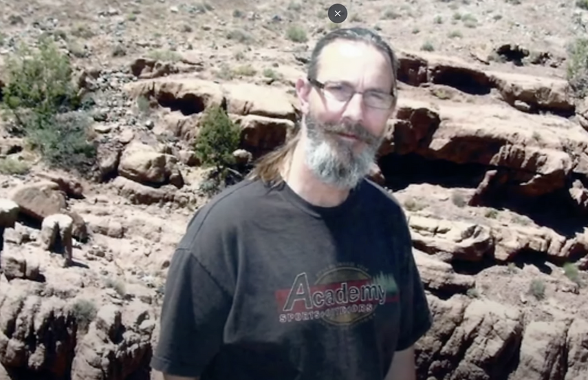
Dale Stehling
The trip to Mesa Verde and the Spruce Tree House Ruin
On June 5, 2013, Dale, his wife Denean, and his parents, Deri and Gloria, set out on a road trip in their RV from Texas. They planned to visit several states, including Colorado. By June 9, they had already visited the Canyon de Chelly National Monument in Arizona, but when they entered New Mexico, the RV started having troubles, so they were forced to stop and get it fixed in Colorado.

Dale, Denean,Deri and Gloria Stehling June 2013 Canyon De Chelly National Monument
While it was in the repair shop, the Stehling family decided to take a trip to the Mesa Verde National Park later in the afternoon on June 9. Initially, the plan was to drive around the park and stop at some of the lookout points, as it was a hot day. The trails in the area were rugged, and since Denean was overweight and Dale’s parents were elderly, it would not have been possible for them to hike it easily.
Then Dale saw the famous Spruce Tree House, the ruins of multi-room dwellings built into stone cliffs by ancient Pueblo people. The ruins immediately caught Dale’s attention, and he was determined to take the short hike to check them out. At the time, the Spruce Tree House Ruin was accessible, but it has been closed to the public for some time.
The park's temperatures that day ranged from 90 to 100 degrees Fahrenheit (32-35 °C). The terrain consisted of steep canyons and mesa tops at an elevation between 6,500 and 8,000 feet.
The hike to the ruins is short, at around 1/4 of a mile, and should not have taken long. The parking lot that the group had pulled into is right next to a ranger station and gift shop. From the top of the Mesa, the Spruce Tree House can be easily seen, and visitors can generally get there without too much trouble, even on a hot day.
Despite their proximity, Dale was the only one interested in checking out the ruins. Before he departed for the short hike, Denean offered him some water, but he declined as the hike was so short. He headed off down the trail at around 4.15 p.m. and disappeared behind a switchback. Denean called to him and asked him to turn around for a picture. Dale, perhaps not hearing her, called back, “I'll see you in a bit.” That was the last she saw of him.
The short loop hike should have taken only 30-40 minutes, with enough time to check out the Spruce Tree House, but after waiting for several hours, Dale was nowhere to be seen. His parents and Denean began to get concerned as they had seen many people head to the ruins and return without incident, so Denean decided to speak to the Park Rangers. They told the family to wait a few more hours in case Dale had decided to go on a longer hike, but by 7.20 pm, he still hadn’t shown up, and the NPS started an initial search of the area before darkness descended.
At first, the rangers thought he had gotten off track. “The park never had a person go missing for more than a couple of hours," said the park’s public information officer, Betty Lieurance.
Dale wore a Khaki Mesa Verde Museum Association Baseball cap, brown tee-shirt, tan/khaki shorts, calf-height white socks and Red Wing Oxford walking boots. He also carried his wallet and some cigarettes.
About Mesa Verde National Park
Mesa Verde (Spanish for "green table") National Park is an American national park and UNESCO World Heritage Site in Montezuma County, Colorado. The park protects some of the best-preserved ancestral Puebloan archaeological sites in the United States. It was the first national park of its kind, established in 1906 by President Theodore Roosevelt to protect the legacy of the Puebloans who lived in the area for over 700 years.
The park occupies 52,485 acres (21,240 ha) near the Four Corners region of the American Southwest. With more than 5,000 sites, including 600 cliff dwellings, it is the most significant archaeological preserve in the United States. In addition to the dwellings, there are many watchtowers, petroglyphs, amphitheaters, pit houses, granaries, and the mysterious, sunken ceremonial structures known as kivas. The park is best known for structures such as Cliff Palace, which is thought to be the largest cliff dwelling in North America.
Starting c. 7500 BC, Mesa Verde was seasonally inhabited by nomadic Paleo-Indians, known as the Foothills Mountain Complex. Later, Archaic people established semi-permanent rock shelters in and around the mesa. By 1000 BC, the Basketmaker culture emerged from the local Archaic population, and by 750 AD, the Ancestral Puebloans had developed from the Basketmaker culture. By the end of the 12th century, they began constructing the massive cliff dwellings for which the park is best known. By 1285, following a period of social and environmental instability driven by severe and prolonged droughts, they abandoned the area. They moved south to Arizona and New Mexico locations, including Rio Chama, Pajarito Plateau, and Santa Fe.
The ancient Mesa Verde structures are highly sophisticated, and the geology is unique. The high Colorado Plateau is the point of centralization for meteorological systems, which originate there and then deliver precipitation to the Central United States. Human habitation in the region stretches back to the Clovis, Folsom, and the archaic periods, 9500 BC to 6000 BC, which allegedly culminated into the so-called Basketmaker Culture around 1000 BC. The Basketmaker Culture morphed into the Ancestral Puebloans, also known as the Anasazi, about 900 BC. These later cultures are notable in the archaeological record for their master planning and the astronomical alignments of their villages, for their mysterious/sudden disappearance, and for evidence suggesting ritual murder and cannibalism.
The modern tribes of the area are the Navajo, Zuni, Paiute, and Hopi, but the tribe most closely associated with the ruins is the Ute. The Ute were adamantly opposed to the so-called “land swap,” which enabled the US government to take possession of these ruins. So, significant anger, animosity, and controversy regarding this entire region is associated with a wide range of strange, ancient stories.
In the late 19th century AD, a family of local ranchers named the Wetherills established trust with the Ute, who told the family, “Deep in that canyon and near its head are many houses of the old people—the ancient ones. One of those houses, high, high in the rocks, is bigger than all the others. Utes never go there; it is a sacred place.”
In the article “Riddles of the Anasazi: What Awful Event Forced the Anasazi to Flee their Homeland, Never to Return?”, explorer and author David Roberts and his colleagues consulted with archaeologists and explored usually off-limits sites in Colorado and Utah.
Roberts addresses the overlooked (by archaeologists) issue of how and why many of these cliff dwellings were built so high up in steep canyons. “We were intrigued by the question of why the villages were built high in the cliffs, but we were equally fascinated by the “how”—how the Anasazi had scaled the cliffs, let alone lived there. During our outings, we encountered ruins that we weren’t sure we could reach even with ropes and modern climbing gear, the use of which is prohibited at such sites. Researchers believe the Anasazi clambered up felled tree trunks that were notched by stone axes to form minuscule footholds. These log ladders were often propped on ledges hundreds of feet off the ground. (Some of the ladders are still in place.) But they would not have been adequate to reach several of the dwellings we explored. I believe that archaeologists—who are usually not rock climbers—have underestimated the skill and courage it took to live among the cliffs. Beneath us, the cliff swooped 150 feet down, dead vertical to a slope that dropped another 450 feet to the canyon floor. The settlement, once home to perhaps two families, seemed to exude paranoia, as if its builders lived in constant fear of attack. It was hard to imagine elders and small children going back and forth along such a dangerous passage. Yet the ancients must have done just that: for the Anasazi who lived above that void, each foray for food and water must have been a perilous mission.”
Many structures are intertwined within the 400 miles (644 km) of ancient Anasazi “roads,” among the obscure, seemingly secretive archaeological excavations of these sites have been found the remains of an elite class of hominins with extra fingers or toes. This trait was viewed with a certain degree of reverence, and some researchers, like those of Project Gutenberg, have speculated that in ancient times, a ruling class may have subjected the natives of the region.
Anthropology professor Christy G. Turner of Arizona State University, in his publication, “Man Corn”, showed that not only did a great deal of cannibalism occur here, but that it was on an unimaginable scale. The scale of cannibalism was so great that Christy rejects the notion that this practice was a reaction to a starvation crisis, instead suggesting it was a form of psycho-spiritual/social control. Many of the Native American traditions regarding this area are taboo and not up for discussion even amongst themselves, and even more so towards Westerners.
However, the Paiute do have one well-known legend that revolves around an archaic, cannibalistic people who inhabited the region before them and who were subsequently driven out by violent force. The Si-Te-Cah, according to Sarah Winnemucca Hopkins, daughter of Chief Winnemucca, were a savage culture of large, red-haired natives who would execute nighttime raids on her people, abducting women and children to be devoured. Large skeletons (which have vanished) are said to have been unearthed by guano miners within Lovelock cave, along with smaller human remains which had been cracked open for removal of the bone marrow. Despite the disappearance of these large remains, the mainstream academic community does not deny their existence. The archaeological site at Canyon de Chelly did, in fact, contain a huge collection of exclusively child remains.
Spruce Tree House Trail

Spruce Tree House Ruin
Spruce Tree House is a self-guided tour of a well-preserved cliff dwelling inside Mesa Verde National Park. Since 2016, due to safety concerns related to rock falls from the alcove surrounding Spruce Tree House, the cliff dwelling has been closed for the foreseeable future until a full geotechnical assessment can be performed.
The trail began at the Chapin Mesa Archeological Museum and descended 100 feet on a paved winding path, before ascending back 100 feet on the same path.
Spruce Tree House is the third largest cliff dwelling (Cliff Palace and Long House are larger) and was constructed between 1211 and 1278 CE by the ancestors of the Pueblo peoples of the Southwest. The dwelling contains about 130 rooms and eight kivas (kee-vahs), or ceremonial chambers, built into a natural alcove measuring 216 feet (66 meters) at its greatest width and 89 feet (27 meters) at its greatest depth. It is thought to have been home to about 60 to 80 people.
The cliff dwelling was first discovered in 1888 when two local ranchers chanced upon it while searching for stray cattle. A large tree, which they identified as a Douglas Spruce (later called Douglas Fir), grew from the front of the dwelling to the mesa top. It is said that the men first entered it by climbing down this tree, which another early explorer later cut down.
It was opened for visitation following excavation in 1908 by Dr. Jesse Walter Fewkes of the Smithsonian Institution. Dr. Fewkes removed the debris caused by fallen walls and roofs and stabilized the remaining structures. Due to the alcove's protection, 90% of the material seen, such as walls, wood, and plaster, is original.
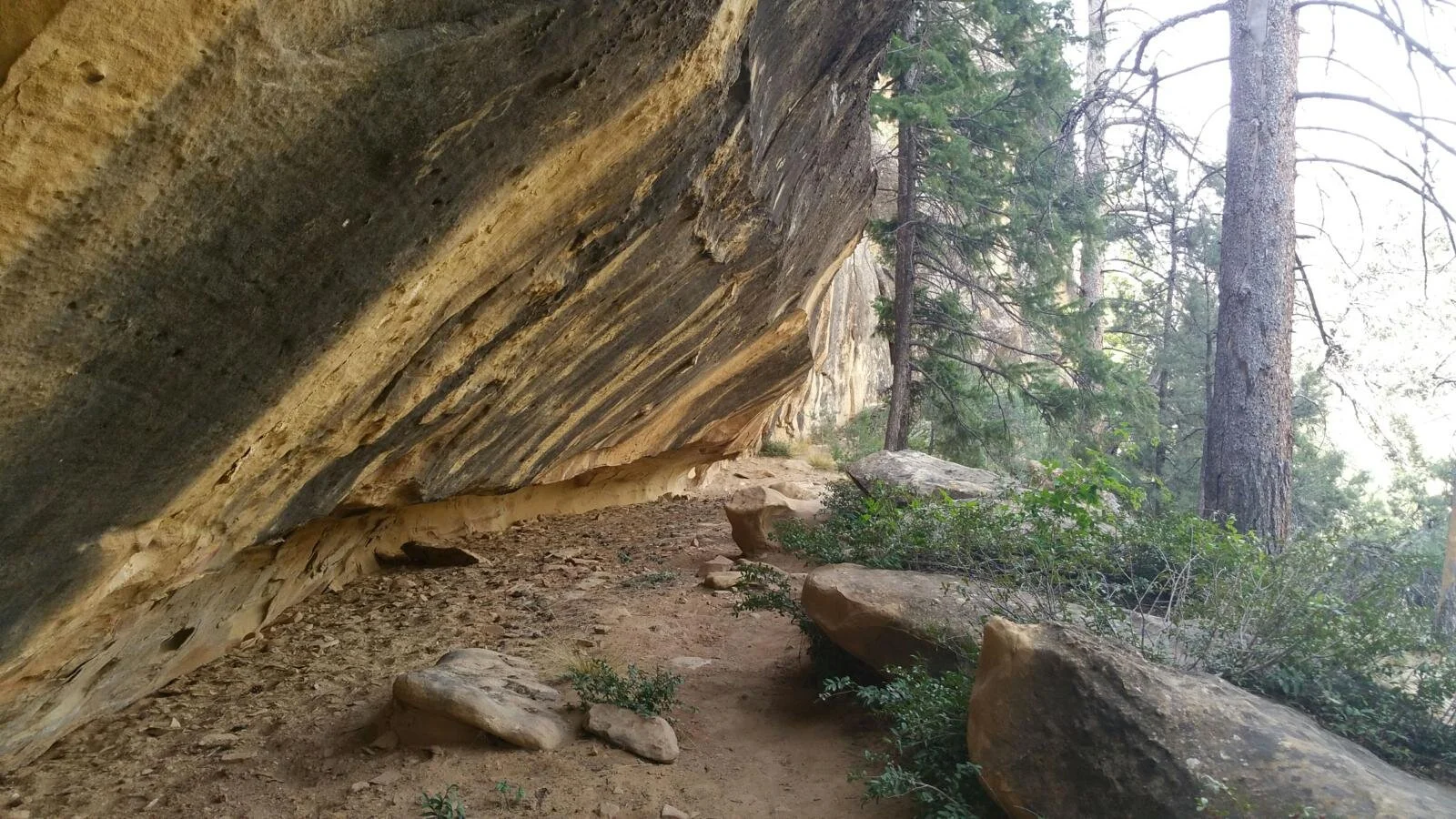
The Petroglyph Point Trail

The petroglyph panel located 1.4 miles (2.3 km) from the Petroglyph Point Trailhead.
The Petroglyph Point Trail is a 2.4-mile (3.9 km) loop trail described by the NPS as “narrow, rugged, and rocky, with several steep drop-offs along the canyon wall on the way to the petroglyph panel. It has a 174 ft (53 m) elevation change and takes around two hours to complete.
After the panel, you’ll scramble up a large stone staircase using hands and feet to climb to the top, then enjoy an easy return through the forest to complete the loop.“ AllTrails describes the trail as moderate in difficulty, “Half the trail is easy, and half is hard. Worth it. Go counter clockwise to get the hard half out of the way first. The petroglyphs are just about halfway. There’s a long, steep scramble up after that, but the rest is easy, mostly flat.”
The trail offers excellent views of Spruce and Navajo Canyons and passes a large petroglyph panel located 1.4 miles (2.3 km) south of the trailhead.
The trail follows a trail of the Ancestral Pueblo people into the forested Spruce Canyon landscape and along a sometimes steep, rocky path back to the canyon’s rim. At one time, this path connected the community at Spruce Tree House with other outlying sites within the canyon and the rest of the Pueblo community.
The large petroglyph panel on the trail represents the written language of the people who inhabited and travelled through this canyon. More than thirty human and animal figures, spirals, and handprints cover an area of over 35 feet wide.
The disappearance of Dale Stehling
The next day, June 10, an intensive two-week search began. At its peak, it included 60 searchers, two dog teams, helicopter surveillance, and rope teams that rappelled off cliffs in the Chapin Mesa area. The K-9 team initially showed interest in the region in the first days of the search.
Searchers knew where Dale intended to go, but it was doubtful that he got lost on the short Spruce Treehouse Trail, and early investigations revealed he had been spotted on the Petroglyph Trail, another loop trail around 2.4 miles long. He had either gotten lost or wanted to tackle the longer trail. The trail follows a canyon wall before coming to the Petroglyph panel that the trail was named after, and beyond that, the trail climbs up and returns to the Spruce Tree House area.
This news quickly concerned Searchers, as Dale carried no supplies, especially water. Although much of the trail was in the shade at certain times of the day, it was hot.
Denean speculated that her “directionally challenged” husband, hiking without water or a map on a hot and sunny day, might have been misled by a sign pointing to the Chapin Mesa Archeological Museum and inadvertently went off trail.

Retired Judge and Dale Stehling at the Petroglyph panel (last photo of Dale)
A family hiking the trail that day, including a retired judge, told Stehling’s wife they leapfrogged past one another and were together at the petroglyph panel 1.4 miles from the trailhead, but they never saw him afterwards. When they heard that Dale had gone missing, they looked back at the photographs they had all taken that day and realized that they had actually captured a picture of Dale at around 5:00 p.m. They recalled Dale saying he better hurry on as he had people back at the trailhead waiting for him, but he seemed relaxed, and nothing he said or did worried the family. This was the last sighting of Dale on the trail, though later, there were reports from a hiker on the Petroglyph Point Trail who claimed to have heard someone calling for help.
On June 10, searchers reported a partial ping from Dale's cell phone. Around 7 p.m. that day, his phone attempted to make a call to its voicemail, but after that, all calls went directly to his voicemail.
Petroglyph Trail
According to Patrick O'Driscoll of National Park Services Media Services (intermountain region), other than the main trails, the majority of Mesa Verde is uncharted territory that is off-limits to hikers.
Jesse Farias, chief ranger for Mesa Verde National Park at the time, said the area had been heavily searched but with no results, “In November, we had a dog team come in and search that area again for human remains, but they did not pick up any hits. When we have search-and-rescue exercises, we go there and continue to look but have not found him.” Jessie retired in April 2022, after 35 years with the National Park Service, including the last 19 at Mesa Verde National Park. He had also worked at Grand Canyon and Yellowstone National Parks during his long career.

Jesse Farias
The authorities determined that, in their view, no foul play was suspected. Farias said, “My gut feeling is that he is out there somewhere and never left the park. There is no reason to think otherwise – there have been no sightings. The case is still open. Not one physical clue has been found, and he is presumed to have died in the wilderness.”
After the official search was called after two weeks, the NPS didn’t close the case on Stehling and continued to look for him in a limited continuous mode. This means that if a ranger is in the park, he or she will remember that there is an unfound body in the park and be aware of any evidence that may lead to his recovery.
Chief Ranger Farias said a photo of Dale Stehling and notes about his disappearance remained on his wall. Although about five to ten people go missing in the park yearly, they are found, and the case of Dale Stehling stuck with him.
Farias said the park extended its efforts for months to find Stehling, including calling in close to 100 people to search, scaling cliffs, and scouring park areas closed to visitors.
Many cliff areas in the park extend down to the Ute Mountain reservation filled with rocks, and Farias said if Stehling fell down a cliff, it would be almost impossible to see him from above or below it. "If he fell off a cliff, if he fell in between a rock area - unless you are looking straight down, even helicopters would not see him.”
Authorities shared case files with the family and informed them of the search activity. But Dale’s wife, Denean, didn’t think the Rangers did enough to search for her husband, saying they spent just two days properly searching for Stehling before scaling back. A news release cited a lack of evidence regarding Dale’s exact whereabouts and reason, but it was clear he was last seen on the Petroglyph trail. One year after he went missing, she said, "Now that it's been a year, and the more I reflect on it, honestly, I'm just pissed off. Their attitude was: He was there, he was lost, and what are they supposed to do about it?"
But Farias countered Denean’s strong views, saying that park rangers searched for Stehling for about three months, mainly in a scaled-back mode, and continued to keep his disappearance on their radar. Their searches, he said, “have and continue to cover a 3 to 5-mile radius around the trail he was last seen on”.
Mrs Stehling, however, wanted the search to extend out of the small area as, despite her husband’s age, he could put more miles in a day than they thought, but nothing came of it.
Throughout 2014, Denean returned to the park three times, expecting answers, expecting to find her husband, and hoping for some closure, but each time she returned, nothing changed. She believes her husband went off the trail because of confusing signs in the park. Because she could not walk the trail, she fed her theory using the account of a family who'd last seen her husband on it.
Jodi Peterson’s article

Jodi Peterson
There is an account of writer and hiker Jodi Peterson, who was in the park the same day and on the Petroglyph Point trail, written in June 2013 called “About a disappearance in a national park” and published in High Country News.
She wrote in her article:
After an hour of walking, I suddenly heard a weary male voice call, “I need some help.” I thought of the missing hiker. Perhaps after visiting Spruce Tree House, he’d attempted this trail and run into trouble. I called out several times, but got no response. I thought about going off-trail to look, but figured I’d become Victim No. 2 if I tried to scramble down those ledges and cliffs. My cellphone had no signal.
I hiked back down the trail as fast as I could, and when I found the chief ranger, I told him what I’d heard. Relief washed over his face as another staffer said, “We thought we heard a call for help in that area yesterday.” They quickly began planning to bring in dogs and more searchers. I left the ranger station and stood looking at the opposite side of the canyon, where I’d heard the call. I said a silent prayer.
When I got back to my western Colorado home the following day, I checked the news, thinking I’d read that the hiker been found. Instead, I learned that Mitchell Dale Stehling was still missing, and now, 70 people were looking for him.
As I write this, it’s been almost two weeks since Stehling vanished, and the search has been scaled down. “A group of us think he’s still somewhere in the park,” said chief ranger Jessie Farias. “We’ve all heard of planned disappearances, but it doesn’t smell that way.”
The odds of him being found alive are basically zero, though. Perhaps he fell between big rocks in a place where searchers can’t see him; perhaps wind shifts made the dogs miss his scent.
Dying alone in the wild sounds like a free and romantic way to exit this earth, and many of my outdoor friends say they’d prefer to perish outside. “Like Lawrence Oates,” I’ve told them in agreement, remembering the member of Scott’s ill-fated 1911 polar expedition who walked out into a blizzard to die. “On some freezing cold night, I’ll say what he did: ‘I’m just going outside, and may be some time.’”
My friend Albert imagines another sort of ending: “My last moment will be at 12,000 feet in a thunderstorm. There’ll be a big flash and all that’ll be left is my flask and my hiking boots.” And Joe has already picked out a sleeping bag to be buried in.
But is that really how any of us wants to die, alone in the wilderness, unattended except by beetles and vultures? Better, I think, to be with those you love.
The remains of Dale Stehling discovered in September 2020
Cold Case Resolved: Mitchell Dale Stehling Located
According to the NPS, an anonymous tip submitted via the NPS-wide Tip Line led to the discovery of human remains in a remote area of the park. US Park Rangers, an ISB Special Agent, and personnel from the Montezuma County Coroner's Office located and recovered the remains on September 17, 2020. The remains and some personal items were found approximately 4.2 miles from the point where Stehling was last seen in June 2013. A medical examiner positively identified the remains as those of Mitchell Dale Stehling.
Mesa Verde National Park Superintendent Cliff Spencer said an anonymous tip the day before indicated the remains of Dale Stehling were in a remote section of the park west of Durango. The tip did not provide an exact location, but its descriptions gave search crews a good idea of where they were. In an email to the Durango Herald, park spokeswoman Cristy Brown said: “Due to the fact that the remains were found in a closed area, by someone hiking off trail in a closed area, and because of the cultural sensitivity of the park and its resources, and to prevent others from also hiking off trail, causing resource damage, and potentially turning into additional search and rescue cases, the park will not be releasing the exact location name”.
Spencer said the body was found “quite a distance away” from where Stehling was last seen - around 4.2 miles. The area, which took search crews about two hours to reach, was searched in 2013 when Stehling went missing, yet no sign of him was found despite the use of cadaver dogs.
Montezuma County Coroner George Deavers said he was “99%” sure the remains were that of Mitchell Dale Stehling because of items found at the scene: a driver’s license, credit cards, and a Social Security card that had Stehling’s information on it.
Deavers said he is going to meet with a forensic anthropologist to examine the remains, looking for any signs of trauma or any clues that can explain the circumstances surrounding Stehling’s mysterious death. He also said that as of late September 2020, foul play was not suspected, and it did not appear an animal attacked him.
Because the remains were just bones, Deavers said it was likely impossible to determine a cause of death unless Stehling had obvious signs of trauma, which he did not. “Just from what I saw, (I’d say) natural causes. But we’ll look everything over.”
It was unclear whether a DNA test was possible at the time of the discovery. The bones must retain some moisture to take DNA from a sample; many of them found at the scene were bleached. If a DNA test is possible, Deavers said it would take about a year to get the results back. He also said Dale’s remains were found by a hiker in an area that is closed to the public, at the bottom of a canyon, and it is believed that is where he died.
The finding of Stehling’s remains ended a more than seven-year mystery, including searches for clues as recently as November 2019.
What happened to Dale Stehling?

Missing person poster Dale Stehling
At first sight, the case seems straightforward. Another case of outdoor misadventure - rocks, cliffs and heat can all be deadly. Dale Stehling's family appears to have gotten closure after a seven-year wait. His wife said Dale was "directionally challenged," meaning he was unable to keep track of where he was, and that, together with the effect of heat, is the most likely cause of death in this case. He might have been misled by a sign pointing to the Chapin Mesa Archeological Museum and inadvertently went off trail. Once lost, it is easy to panic and head in a direction to get help, leading to further trouble.
However, questions remain about the circumstances of his disappearance and death.
Why didn’t the NPS release the location of the remains?
Officials said that the remains were found 4.2 miles from the point where Dale was last seen and apparently at the bottom of a canyon that had been searched. The Remains were only found because an anonymous caller pointed searchers to the correct location. This Anonymous person was hiking somewhere off the Trail in an area closed to the public and in the middle of nowhere. Why did they decide to remain anonymous? Were they involved in the case or undertaking criminal activity? Going off trail in this location would be foolhardy and illegal. It is dangerous terrain, and what are the odds of coming across Dale’s skeletal remains seven years after his disappearance? Slim, very slim.
The NPS stated that they were worried about “the cultural sensitivity of the park and its resources, and to prevent others from also hiking off trail, causing resource damage, and potentially turning into additional search and rescue cases, the park will not be releasing the exact location name”. This sounds like a flimsy explanation for the reason they stated the remains were located west of Durango in a remote section of the park, which is an utterly vague statement as this means the remains were found somewhere East or Northeast of the Petroglyph Trail and 4.2 miles as the crow flies meaning that Dale must have walked a considerable distance before he succumbed in terrain which is incredibly difficult to walk with no water and sweltering conditions. Because of the canyons and ridges, it's virtually impossible to walk in a straight line because the eastern half of the park pretty much has nothing in it in terms of trails or roads,
If the exact location were released to the public and Dale died, would they be encouraged to head into the wilderness in a closed part of the park? It would make little sense, especially if an approximate area description were published.
It’s not difficult to imagine that a hiker exploring an off-limits park area would elect to remain anonymous. The vast majority of the enormous 52,485-acre (21,240-ha) park is off-limits. However, the designation “West of Durango” is very strange because the town of Durango is thirty-eight miles (61 km) east of the park. However, the park's largest and most remote area (all of which is suspiciously off-limits) is in this section directly west of Durango.
Given the park's geography, this 4.2-mile (6.8-km) distance is troubling because it could only have been to the west or south. Towards the east would have led right back to other paved road areas of the park with another visitor centre, etc., and to the north would mean he would have gone down into a canyon and scaled back up the other side, which would have been virtually impossible. Neither south nor west would align with the reports that he was discovered “West of Durango.”
Despite the case being closed when the remains were found, the NPS refuses to release further information to interested parties.
Why did an extensive search effort fail to turn up any sign of Dale, and why did it take seven years to locate his remains?
The search for Dale was extensive and carried out over two weeks. It included 60 searchers, two dog teams, helicopter surveillance, and rope teams that rappelled off cliffs. Yet, he was missed, and it took seven years to locate the remains by an anonymous tipster. The sniffer dogs could not detect a scent despite perfect weather for scent detection.
Moreover, Mesa Verde Park is relatively small, and the popular hike to the Spruce Tree House ruin is also reasonably straightforward. However, the Petroglyph Trail is much more challenging, and it appears that Dale decided to hike this trail. Some hikers report you can get off-trail, but it is reasonably well marked. Of course, the area is rugged, and it was hot when Dale disappeared. Perhaps he was unlucky, got confused or dehydrated or just fell. It was bad luck. But to end up 4.2 miles away as the crow flies (likely over 10 miles walking) from where he was last seen without water or supplies was quite a feat, but not impossible for a man of Dale’s age in a survival situation.
Submitted by Rena Walls on August 28, 2021 - 3:57 am National Park Traveller, “We were on that trail this past June, you cannot easily get off trail (I am directionality challenged), there is an obvious trail. I will say though that after the petroglyph panel (where he was last seen), you do have to climb straight up a wall, which for an older person (I am 64) can be a challenge. A younger couple waited to help us as they knew it could be dangerous. If you lose control and fall backward you will fall off of the trail and down toward the canyon floor, it is my guess that this is what happened to this poor soul. It would be nearly impossible to climb back up; perhaps he just continued down and onward in hopes of finding help or finding his way out. This is truly sad as he was quite close to safety“
Could foul play have been involved?
Perhaps Dale was on a mission to find illegal souvenirs in an off-trail area and was confronted by someone. It seems unlikely, as he told his family he would only be hiking for a short period.
Why didn’t sniffer dogs detect scent?
If Dale had fallen off the trail and into a crevice, the K9 units surely would have detected his pungent scent emanating from within, and his remains would not have been discovered so far away.
Family feedback on the case
On the National Parks Traveler site, Martha Elizabeth (Marcy) Stehling posted on May 19, 2023 at 8:39 pm.
“I'm Dale's older sister. Every so often I google his name and just read articles, watch videos about his case. My family and I were devasted to lose Dale in such a weird way. On June 9, 2023, we mark ten years since he went missing. I'm still not over it. He was my best bud in the world. You raised some interesting questions.
I can clarify a couple of things, one is that Dale was not military, but our father was; we grew up as Army Brats from baby up. Dale did hike a lot, but really only in the pastures surrounding his home in the country. He was not, as I've seen elsewhere, a survivalist by any means, although he was pretty dang tough. He was physically disabled, due to a number of back surgeries that ultimately caused him to have a stooped over posture and a funny gait, but the man could walk for a long time, probably longer than the searchers would have thought.
I went out to Mesa Verde on June 9, 2014, and hiked the Petroglyph Trail.. alone. There were two places where I lost the trail. Somehow, I got off and then back on the trail, thank God, and also when I reached a certain point, I walked out of foliage into a big clearing with a solid rock ground and a cliff with a drop off that took my breath away. No guard rails. Also, I could not see where the trail picked up across the clearing, and stood still for a time just slowly looking around, until I spotted a little bitty pile of rocks stacked one on top of another; I walked over to it and immediately saw the opening for the trail. It was an emotional experience, and I no longer go alone into the wilderness. We were able to have services for my brother, and he is buried under a big live oak tree on his property in South Texas. I will miss him for the rest of my life.”
Submitted by Denean Stehling on September 26, 2020 - 11:40pm, “Have you actually been there and hiked? It's not an easy trail to get lost on. Even if he has gotten lost on the pinion trail he would not have ended up down at the bottom of a canyon on the east side of the park. Not unless he willfully and purposely hiked the top trail at the very end of the hike where you can see the gift shop et of the spruce treehouse area. why would he go directly to hike the petroglyph trail rather than simply the spruce treehouse little walk right there to see the ruins as he had supposedly told his wife. Even if he had just decided spur of the moment to hike the Petroglyph trail it would have taken only about an hour and then you are right back wheee you started. Other people last saw him in an area close to the end of the hike. If he further and without water decided to hike the top road over to say balcony house or the sun temple how did he end up at the bottom of a canyon dying from natural causes. There is no way down but to jump or fall. Did he commit suicide? did someone take him there another way as in by car and hike in from canyon side? Was he invoved wi something illegal? Was he meeting up wi someone for some reason? What was his occupation? nothing on internet. Family says he's ex military. Did he know secrets. is it a cover up? What the heck is going on that is what I want to know. This is not the type of place you wonder off and get lost unless you want to. Even if he were disoriented from dehydration there area is fairly populated wi tourist espec on a Sunday in June. Someone would have seen him and helped.
I am not puzzled by any of this. Let me clarify for yall. The first 2 days the search was around the 2 public trails in the park. Once the park made it public and posted a missing poster 2 days in, a family cam forward and said Dale was on the trail with them. At that point the dogs were brought in and focused only in the area where last seen. They did extensive search for 3 more days in the area. I stayed in the park for 11 days, after the 5th day the search was scaled back to only a few Rangers. I finally left the park after several days of being told we didn't get search today. So intense search was 5 days. All focused near where last seen. Another thing many people don't realize is Mesa Verde is a restricted park so not anyone can search. Only park employees. When the dogs came in they had to have Rangers with them. I think if the dogs would have been there day 1&2 they would have found him. The dog team was there 1 day and then another team returned on July21st. So it is very misleading when they say how extensively they searched.”
The Missing Enigma
On September 26, 2024, the YouTube Channel The Missing Enigma released a video called “Is Something Strange Happening At Mesa Verde? The Search For Dale Stehling.” Like many on his channel, the video is well worth watching. Much of the recent content has been very well researched, with visits to the locations where the various cases took place.
The host, Nick Kyle, has an interesting perspective on the Dale Stehling case, summarising his video as follows:
“People get lost on the Petroglyph Trail yes I suppose you could but you can't really get very far without falling off the cliff side the only place you can really go off Trail is up top on the plateau and once you start walking up there you're going to hit a road again we're really only left with the possibility that these guys fell or something and sure the weather at Mesa Verde can be extreme but when Dale was last seen he was reporting as being fine.
Dehydration didn't seem to be a problem. They said he looked relaxed and unconcerned, and he was about halfway done with his hike at that point, but that area right after the petroglyphs is dangerous and confusing. One thing worth mentioning is that all Trails show a short secondary trail that shoots off from the middle of the Petroglyph Trail and takes you toward the bottom of the canyon. When I was up there, I didn't notice it, nor did I see any signs for it. Mesa Verde certainly doesn't advertise it, as it's not on the maps that they give to visitors. Still someone who's confused or maybe someone who didn't look at the trail before hiking like Dale could possibly get confused and take this offshoot.
If you didn't know you were supposed to go up at the end of the canyon, you could be forgiven for thinking that the trail just goes on this Trail is not well marked it's possible Dale or even Thomas could have gone down this way but then what if the option is to walk off Trail and down the canyon or turn back why would you choose to go off Trail whatever happened to Dale it seems that he couldn't get back up to the trail as evidenced by those calls for help.
He was known as “The Walking Man” to his family, so maybe he tried to walk his way out of there. Still, if he was found in the eastern half of the park, he would have had to walk south, then east, then north basically, you'd have no choice but to follow onr of the Canyons, and that would add up to one hell of a journey. But it's the only way to get to the eastern half that would avoid. Crossing one of the major roadways in the park there is a part of me that wants to simplify the explanation to this case by saying maybe Dale fell into Spruce Canyon and just started walking North.
To me, this would be the Occam's razor explanation. To get the requisite 4.2 miles, he would have had to walk North up Navajo Canyon or another canyon and die there. That would make a lot more sense in terms of a location where you might find a body. But then I think about what the Park Service said: the remains were found in a remote location closed off to the public. Does this location really qualify? It's a mile or less as the crow flies to the nearest Main Road, depending on which Canyon you're in.
I don't consider that very remote, and if Dale simply walked north in essentially the same Canyon he fell into, then why wouldn't the park just say that? Why not say Dale Stehling died 4.2 miles north of where he disappeared? Apparently, after descending into Spruce Canyon, the park doesn't even offer their own speculation as to what happened, and if Dale was inclined to walk north, why not walk North in Spruce Canyon? I mean, if you accidentally fall into a canyon, why not follow it back the way you came? He knew the spruce tree terrace was back that way. If he was calling to people on the Petroglyph Trail, then he still had an idea where the trail was, so why not follow it back to salvation?
IfD ale had walked North up Spruce Canyon it would have taken him to a road in roughly 3 miles but he really didn't have to do all that if he had just walked a little ways up Spruce Canyon he would have hit the spruce Canyon Trail which literally runs along the very bottom I mean there are people hiking there people that could help him he wouldn't be trapped down there there was an easy way out that means if he fell he was less than a mile from an easily accessed Trail that's in use throughout the day even if he didn't see people walking the spruce Canyon Trail the trail itself would have been obvious he could have followed it n either direction and it would have taken him back to the spruce tree terrace if he was able to walk 4.2 miles as the crow flies he must have still been in Fairly good condition so why didn't he try walking back the the way he had come instead he apparently did something else or something else happened to him and the park service has no interest in clarifying where he was found or what happened it would have been so easy for them to Simply name the canyon Dale was found in doing so would do nothing to harm or affect any of the things the Park Service listed in their statement so to be clear while it's odd in itself that Dale didn't try walking up Spruce Canyon it would make make the most sense that he traveled North and died but that doesn't seem to fit very well with what the Park Service did say about where his remains were found if he went South the journey back to a Northeast sector of the park would seemingly be impossible because of the layout of the Canyons.
All of this adds up to a bit of a mystery this explanation while I do like it more than Portals, is pretty unsatisfactory, and as for Thomas Irwin we're over 6 months into his disappearance and still, he hasn't been found, obviously at this point he's no longer alive, but I do wonder if he ever is found will it be in a remote area of the park similar to Dale you'd think not because he was quite a bit older and less fit so we got two people disappearing from this same Trail for unknown reasons we got people who are wandering in off-limits areas of the park finding evidence and remains and a body location that the park doesn't want to make public and again that doesn't make sense to me that information ipublic record, and for years now they won't give it to me despite my attempts is something odd happening at Mesa Verde
I can't say for sure or not, but there are too many unanswered questions here for a case that's been closed for years with a body being found. Let's hope that we get some explanations in the future because I'm going to keep digging on this case.”
Exclusive articles for members of StrangeOutdoors that are not available elsewhere on the site.
See the latest Exclusive members-only articles on StrangeOutdoors.com
Read more strange stories from Colorado
The death of Peter Jeffris in the Rocky Mountains (Member Only)
The mysterious disappearance and death of Doctor James McGrogan in Colorado
The strange disappearance and death of Gene George from Mount Harvard
The mysterious disappearance of Michelle Vanek on the Mount of the Holy Cross
The bizarre disappearance of Keith Reinhard and death of Tom Young in the Rocky Mountains
Michael and Makana Von Gortler’s unexplained deaths on Missouri Mountain
The Strange disappearance of Maurice "Doc" Dametz
The disturbing death of 3 year old Jaryd Atadero on the Big South Trail
The unexplained disappearance and death of Mitchell Dale Stehling in Mesa Verde National Park
The weird disappearance of hunter Alvie Webb in the San Juan National Forest
The strange disappearance of Alfred Beilhartz in Rocky Mountain National Park
The strange death of Joshua Maddux, the Boy in the Chimney
The miracle rescue of Alan Lee Phillips at Colorado’s Guanella Pass - the man who turned out to be a serial killer
Sources
https://www.nps.gov/places/place-ppt-trail.htm
https://www.alltrails.com/ar/trail/us/colorado/petroglyph-point-trail
https://www.nps.gov/meve/learn/historyculture/cd_spruce_tree_house.htm
https://www.alltrails.com/ar/trail/us/colorado/spruce-tree-house-trail
http://charleyproject.org/case/mitchell-dale-stehling
https://durangoherald.com/articles/141040
https://www.ancient-origins.net/unexplained-phenomena/dale-stehling-0015253
https://www.victoriaadvocate.com/counties/goliad/goliad-woman-retraces-missing-husband-s-path-w-video/article_2e932f38-7873-586c-850e-b45c29e1651d.html
https://en.wikipedia.org/wiki/Mesa_Verde_National_Park
https://www.postindependent.com/opinion/columns/about-a-disappearance-at-mesa-verde-national-park/
https://durangoherald.com/articles/339455
https://www.crossroadstoday.com/news/local-news/remains-of-mitchell-dale-stehling-found-at-mesa-verde-national-park/article_699ff452-c104-5842-b648-23f5181e1f4f.html
https://www.nationalparkstraveler.org/2020/09/remains-man-who-went-missing-mesa-verde-national-park-found
https://www.nps.gov/orgs/1563/news-releases.htm
https://www.durangoherald.com/articles/73-year-old-man-goes-missing-in-mesa-verde-national-park/
https://namus.nij.ojp.gov/case/MP115377