
The disturbing Pacific Crest Trail (PCT) disappearances

Revised January 2024
The Pacific Crest Trail (PCT) remains an iconic trail that passes through California, Oregon, and Washington. Several hundred hikers attempt the 2653-mile trek each year, and many complete the trip without incident. However, in recent years, as well as the deaths from falls and drownings, there have been some high-profile disappearances from the PCT.
What is and where is The Pacific Crest Trail (PCT)?
The Pacific Crest Trail (PCT), officially designated as the Pacific Crest National Scenic Trail, is 2,653 mi (4,270 km) long and is aligned with the highest portion of the Cascade and Sierra Nevada mountain ranges. It is largely located 100 to 150 miles (160 to 240 km) east of the U.S. Pacific coast.
The trail's southern end is just south of Campo, California, by the U.S. border with Mexico, and its northern terminus is on the Canada–US border on the edge of Manning Park in British Columbia.
The Trail ranges in elevation from just above sea level at the Oregon–Washington border to 13,153 feet (4,009 m) at Forester Pass in the Sierra Nevada. The route passes through 25 national forests and seven national parks. Its midpoint is near Chester, California (near Mt. Lassen), where the Sierra and Cascade mountain ranges meet.
It was designated a National Scenic Trail in 1968, although it was not officially completed until 1993. The PCT was conceived by Clinton Churchill Clarke in 1932. It received official status under the National Trails System Act of 1968 and is also part of the 6,875-mile Great Western Loop.
Famous sections include the John Muir Trail, Sonora Pass, Sky Lakes Wilderness, Donner Pass and Badger Flat to Little Willow Lake (Lassen Volcanic National Park).
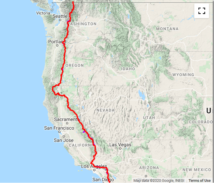
Pacific Crest Trail map
How many people complete the PCT?
The Pacific Crest Trail Association estimates that about sixty per cent of the 700-800 who start it finish each year. Fifty-seven hikers have walked the Trail more than once.
How long does it take to walk the PCT?
It takes most hikers around five months. Elite athletes have finished the trail in as little as two months—the few who achieve sub-100-day hikes average well over 30 miles per day.
Does the PCT have a cell signal?
According to the USDA Forest Service, thru-hikers have roughly 70% of cell phone coverage.
Pacific Crest Trail (PCT) disappearances
Since 2016, there have been several high-profile disappearances on the PCT. Were they just misadventures caused by hypothermia or accidents? The cases of Kris Fowler, David O'Sullivan, and Chris Sylvia remind us of the dangers of some parts of the PCT, especially in the colder months of the year.
The David O'Sullivan case - disappeared April 7, 2017

Irishman David O'Sullivan, 25, with the trail name Leprechaun, planned a five-month hike on the PCT in April 2017. He left Midleton, County Cork, Ireland, on March 20, but David never returned home.
A novice hiker, he started in Campo on March 22 and planned to hike the entire PCT from the border with Mexico to Canada.

David O'sullivan Facebook post March 28 2017
David had spent a lot of time preparing for his trip, regularly tackling Carrauntoohil, the highest peak in Ireland at 1,038.6 metres (3,407 feet 6 inches) carrying weights and transforming his parent's garage into a mini gym.
Having completed a media course as well as a degree in English and Philosophy at University College Cork, David saved money from his job working in a local garage in Midleton to fund his trip.
He was inspired to walk the PCT after reading the book Wild, which also became a film starring Reese Witherspoon.
O’Sullivan is 5 feet 10 inches tall, weighs 154 pounds, has brown hair and blue eyes, wears glasses and has a heavy Irish accent.
He had been hiking for two and a half weeks when he found himself in Idyllwild, a small mountain town at the foot of the San Jacinto Mountain, on April 5.
Idyllwild is a popular holiday spot, and he spent the night at the Idyllwild Inn, a family-owned accommodation. His mum Carmel spoke about the last time he was seen: “He arrived in this little town on the 5th called Idyllwild, it’s about halfway up the mountain two and a half weeks into his hike… He did a few chores, got in touch with all his friends on Facebook and contacted us- everything was going fine. And he was leaving on the morning of the 7th, and he’s not been heard of or seen since.”
Correspondence with his family indicates that David had plans to hike on the morning of the 7th. He had been waiting for an adaptor for his Kindle to arrive at the post office and was considering staying until it opened before he set off the next day, but he was concerned that it may interfere with his schedule. It is unknown whether he tried to pick up the adaptor, but it is certain he never received it as it ended up back at the retailer. An email he sent on that very same morning would be the last communication that David ever made.

There was unusual weather on the San Jacinto Mountain that year, with an unusual amount of snow for so early in the season. There are numerous trails up the mountain, with Devil's Slide being the most popular. But just one day before David was last seen, a hiker reported getting a mile into the trail before encountering snow and turning back around.
David had no alpine experience, but he had told other hikers he had no intention of hiking the snow, and he did not buy any snow equipment before his journey. He did make a $70 purchase at the local outdoor store Nomad's, but the item was not registered at their point of sale. According to the store, all their snow equipment would have been. David was also using a Halfmile map, a brand specially created for the Pacific Crest Trail. The map advised hikers to hike up Black Mountain Road when snow was present to avoid the most dangerous part of the terrain.
David had been working hard at a garage and saved for a year to go on his Pacific Crest adventure. He had visited an ATM before setting off the mountain but only withdrew enough to buy more food at his next stop. A sizeable amount was left in his account and has not been touched since that final transaction. David's mother Carmel and father Con were becoming increasingly concerned at home.
David had warned them that there might be periods of several weeks where he would not be able to get in touch, but feeling that something was wrong, his parents contacted the Pacific Crest Trail Association in April. They were told to sit tight and see if David tuned up. He had arranged to meet a friend in Santa Barbara in May, but he never turned up. Carmel and Con called the PCT Association back, only to be told that they were not a babysitting service and that they could do nothing. As a result, David was not officially reported missing until June 30, 12 weeks after he had last been seen.
A search was launched in White Water Preserve, just north of the San Jacinto Mountain, which would have been en route to David's next scheduled stop. Yet despite using helicopters, dogs, and ATVs, the search and rescue team came up with nothing. There has been little official investigation since then, with no evidence of foul play.
Several hikers have called in eyewitness statements, thinking they may have seen David at some point on the trail. But none of these sightings has been positively confirmed, with most vaguely referring to a hiker with an accent. It has since become known that a German man bears a striking resemblance to David on the trail, and some people may have confused the two.
In December 2017, an aerial survey was conducted over Idyllwild. The pilot, Gus Calderon, and mission specialist Richard McCreight overflew 88 square miles of mountain face and deep desert, taking over a thousand photographs of the ground below. Volunteers analyzed those images in detail, looking for signs of David’s blue backpack.
Gus and Richard used software supplied by AeroScientific to conduct the survey. AeroScientific’s flight planning software (FlightPlanner) and flight management system (Aviatrix) were used to plan the flight runs over Idyllwild and manage the camera system throughout the flight. The aerial survey acquired 1,235 colour images of the area at 4-inch (10cm) resolution.
Regularly, volunteers from San Diego's Irish community still scour the mountain on foot and horses, looking for any signs of David. Drones have been being flown over, grid by grid, while people on the ground examine thousands of images for clues.
The Kris Fowler case- disappeared October 12, 2016

Kris Fowler, trail name “Sherpa”, 34, was completing his NOBO (North Bound) thru-hike in Washington on the Pacific Crest Trail (PCT).
On October 12, 2016, he was dropped off near the trailhead at White Pass (Packwood), where he grabbed a coffee before he headed toward the Canadian border to complete the last 366 miles of his hike. That was the last time he was seen alive.
His last cell phone ping was in that area neat White Pass around 5 p.m. Considerable amounts of snow and freezing rain fell over the next few days. The authorities and volunteers searched the trail between White Pass and the Canadian Border. Yet, no sign of him was found.
While Official Search and Rescue teams under the Yakima Sheriff’s Department did an initial search along the PCT from White Pass in addition to flyovers and road searches, after the initial search, they focused primarily on the area surrounding Blowout Mountain, the location of an unconfirmed sighting by two Bear Hunter’s on October 22. Blowout Mountain is East of PCT MP 2354 (62 miles North of White Pass / PCT MP 2292, where he was dropped off).
Three years later, in 2019, Yakima County Search and Rescue volunteers again conducted multiple searches led by Sgt. Randy Briscoe. Fowler said another 15 to 20 volunteers form what she calls her “team behind the scenes,” a coordinated effort dedicated to combing through areas they know well. But again, nothing was found.
Given the severity of the storm, had Kris made it to Highway 410 at Chinook Pass / PCT MP 2320, 28 miles from where he started at White Pass / PCT MP 2292, he would have pulled out and sought refuge in town very cold, wet and tired as all hikers were that bailed off-trail during the storm. Since he did not do so, it is believed he went off-trail somewhere between White Pass / PCT MP 2292 and Chinook Pass / PCT MP 2320, a 28-mile section. How far off rail is the question?
Some consider any “sightings” from mid-October or later and any search areas North of Chinook Pass / PCT MP 2320, like Blowout Mountain, bogus.
Did Kris succumb to hypothermia on the PCT that October?
The Christopher Stephens Sylvia case - disappeared February 16, 2015, Warner Springs, California

Chris Sylvia was hiking southbound on the PCT from Anza to Campo. He started his trek near state Route 74 in Anza on February 12, 2015, and planned to hike for at least a week before contacting friends to pick him up.
On February 16, he called a friend and asked to be picked up the next day at the Buddhist Temple on Chihuahua Valley Road. Sylvia's roommate went to the designated spot at the agreed-upon time, but Sylvia never showed up. At first, his roommate assumed he'd just decided not to go to the temple.
Search teams from Los Angeles, Orange, Riverside and San Bernardino counties searched in vain for four days before bad weather forced them to suspend the search and rescue operations.
On February 20, another hiker found Sylvia’s gear, including identification, sleeping bag, and backpack, laid out alongside the PCT near mm 127, not far from Mike’s Place. Despite a significant search effort, Sylvia was never heard from again.
Chris was described as an experienced outdoorsman, and his mother stated it would be uncharacteristic for him to go hiking alone or leave his gear behind.
He was wearing a dark-colored fleece jacket, green camouflage-print pants, and brown and black and brown hiking boots. He had brown hair, hazel eyes, a mustache, a tattoo of Asian symbols on his side and a goatee at the time of his disappearance.
Deaths on the Pacific Crest Trail - who involved, causes, and circumstances
See the article on deaths on the PCT trail below:
Exclusive articles for members of StrangeOutdoors that are not available elsewhere on the site.
See the latest Exclusive members-only articles on StrangeOutdoors.com
Sources
https://www.pcta.org/discover-the-trail/
https://en.wikipedia.org/wiki/Pacific_Crest_Trail
https://www.pctmissing.org/
https://www.seattletimes.com/seattle-news/search-continues-for-pacific-crest-trail-hiker-missing-since-2016/
https://www.facebook.com/groups/BringKrisFowlerHome/
https://alpinescience.com/kris-fowler-analysis/
https://www.caseremains.com/post/david-o-sullivan
https://www.thesun.ie/news/2424247/mum-of-missing-cork-hiker-david-osullivan-will-keep-going-until-son-is-found-a-year-on-from-last-contact-with-family-while-on-pacific-crest-trail/
https://www.aerosci.info/uncategorized/aerial-search-for-david-osullivan/
http://charleyproject.org/case/christopher-stephen-sylvia
https://timesofsandiego.com/crime/2015/02/28/inclement-weather-puts-search-missing-hiker-hold/
https://www.heraldnet.com/news/missing-for-8-months-everett-man-found-dead-in-cascades/